


col faita bec charvet Valériane

mout38
User
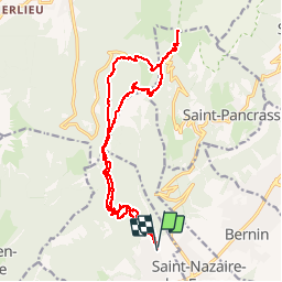

Length
22 km

Max alt
1728 m

Uphill gradient
1724 m
Km-Effort
45 km

Min alt
444 m

Downhill gradient
1731 m
Boucle
Yes
Creation date :
2016-05-16 00:00:00.0
Updated on :
2016-05-16 00:00:00.0
4h41
Difficulty : Unknown

FREE GPS app for hiking
 SityTrail
IGN / Geographical institutes
SityTrail Plus
The world is yours!
About
Trail Running of 22 km to be discovered at Auvergne-Rhône-Alpes, Isère, Saint-Ismier. This trail is proposed by mout38.
Positioning
Country:
France
Region :
Auvergne-Rhône-Alpes
Department/Province :
Isère
Municipality :
Saint-Ismier
Location:
Unknown
Start:(Dec)
Start:(UTM)
722481 ; 5016072 (31T) N.
Comments