


Zevtt - Montlaur

kipoura
User
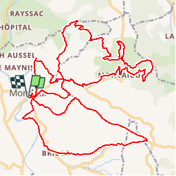

Length
38 km

Max alt
672 m

Uphill gradient
935 m
Km-Effort
50 km

Min alt
333 m

Downhill gradient
940 m
Boucle
Yes
Creation date :
2019-05-03 17:09:53.718
Updated on :
2019-05-03 17:09:54.408
3h11
Difficulty : Medium

FREE GPS app for hiking
 SityTrail
IGN / Geographical institutes
SityTrail Plus
The world is yours!
About
Trail Mountain bike of 38 km to be discovered at Occitania, Aveyron, Montlaur. This trail is proposed by kipoura.
Positioning
Country:
France
Region :
Occitania
Department/Province :
Aveyron
Municipality :
Montlaur
Location:
Unknown
Start:(Dec)
Start:(UTM)
486621 ; 4858403 (31T) N.
Comments