


rando chenove

florianlive
User

Length
38 km

Max alt
524 m

Uphill gradient
869 m
Km-Effort
50 km

Min alt
292 m

Downhill gradient
844 m
Boucle
No
Creation date :
2016-05-22 00:00:00.0
Updated on :
2016-05-22 00:00:00.0
8h27
Difficulty : Unknown

FREE GPS app for hiking
 SityTrail
IGN / Geographical institutes
SityTrail Plus
The world is yours!
About
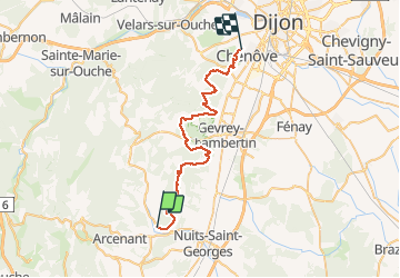
Trail Other activity of 38 km to be discovered at Bourgogne-Franche-Comté, Côte-d'Or, Villars-Fontaine. This trail is proposed by florianlive.
Positioning
Country:
France
Region :
Bourgogne-Franche-Comté
Department/Province :
Côte-d'Or
Municipality :
Villars-Fontaine
Location:
Unknown
Start:(Dec)
Start:(UTM)
643363 ; 5223420 (31T) N.
Comments