


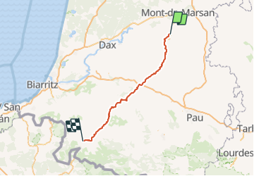
11 St Sever-ST Jean Pied de Port-St Jacques de Compostelle

nicolas54230
User

Length
116 km

Max alt
291 m

Uphill gradient
2365 m
Km-Effort
147 km

Min alt
36 m

Downhill gradient
2230 m
Boucle
No
Creation date :
2016-06-07 00:00:00.0
Updated on :
2016-06-07 00:00:00.0
9h14
Difficulty : Very difficult

FREE GPS app for hiking
 SityTrail
IGN / Geographical institutes
SityTrail Plus
The world is yours!
About
Trail Mountain bike of 116 km to be discovered at New Aquitaine, Landes, Saint-Sever. This trail is proposed by nicolas54230.
Description
Saint Jacques de Compostelle en VTT.
Positioning
Country:
France
Region :
New Aquitaine
Department/Province :
Landes
Municipality :
Saint-Sever
Location:
Unknown
Start:(Dec)
Start:(UTM)
696148 ; 4848878 (30T) N.
Comments