


tour du bois de Le Pesset

COMAN
User
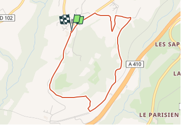

Length
4.4 km

Max alt
827 m

Uphill gradient
112 m
Km-Effort
5.9 km

Min alt
726 m

Downhill gradient
111 m
Boucle
Yes
Creation date :
2017-06-19 00:00:00.0
Updated on :
2022-12-11 15:37:16.68
1h40
Difficulty : Easy

FREE GPS app for hiking
 SityTrail
IGN / Geographical institutes
SityTrail Plus
The world is yours!
About
Trail Walking of 4.4 km to be discovered at Auvergne-Rhône-Alpes, Upper Savoy, Fillière. This trail is proposed by COMAN.
Positioning
Country:
France
Region :
Auvergne-Rhône-Alpes
Department/Province :
Upper Savoy
Municipality :
Fillière
Location:
Unknown
Start:(Dec)
Start:(UTM)
285180 ; 5101839 (32T) N.
Comments