Trail Walking Templeuve-en-Pévèle - Les cache-vaches  - Photo
 camino59
camino59

User

© OpenStreetMap contributors
Length
Length
27 km
Max alt
Max alt
54 m
Uphill gradient
Uphill gradient
140 m
Km-Effort
Km-Effort  
29 km
Min alt
Min alt
25 m
Downhill gradient
Downhill gradient
137 m
Boucle
Boucle
Yes
Creation date :
2016-06-01 00:00:00.0
Updated on :
2016-06-01 00:00:00.0

(0 Reviews)

Walking
Walking
6h20
Difficulty : Medium

Scan this QR Code to open this trail in the SityTrail application

FREE GPS app for hiking

Logo SityTrail SityTrail

IGN / Geographical institutes

Download SityTrail from the App Store Download SityTrail from Google Play

Logo SityTrail SityTrail World

The world is yours!

Download SityTrail from the App Store Download SityTrail from Google Play Download SityTrail on Huawei AppGallery

About

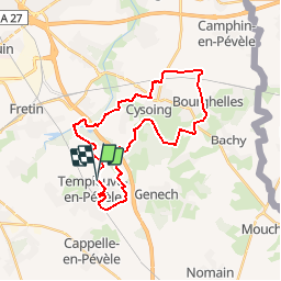
Trail Walking of 27 km to be discovered at Hauts-de-France, Nord, Templeuve-en-Pévèle. This trail is proposed by camino59.

Description

Départ du Moulin de Vertain à TEMPLEUVE. Rejoindre les marais de Bonnance puis direction Cysoing en empruntant une partie du circuit des Osiers. On se dirige ensuite jusqu'à La chapelle aux arbres pour rejoindre Bourghelles et Cobrieux puis retour vers Templeuve via le chemin des cache vaches
Bonne rando

Elevation profile

Positioning

Country:
France
Region :
Hauts-de-France
Department/Province :
Nord
Municipality :
Templeuve-en-Pévèle
Location:
Unknown
Start:(UTM)
512543 ; 5598306 (31U) N.

Trails nearby

Trail Equestrian Cappelle-en-Pévèle - Boucle des Pavés - Capelle en Pévèle  - Photo
Equestrian
tracegps

Equestrian

Medium
(1)
Cappelle-en-Pévèle, Hauts-de-France, Nord, France
17.7 km | 18.7 km-effort
2h 45min
Yes
Trail Walking Ennevelin - Circuit d'Aigremont - Photo
Walking
tracegps

Walking

Medium
(1)
Ennevelin, Hauts-de-France, Nord, France
11.1 km | 11.8 km-effort
2h 45min
Yes
Trail Walking Cobrieux - Circuit de la Commanderie à Cobrieux - Photo
Walking
tracegps

Walking

Medium
(1)
Cobrieux, Hauts-de-France, Nord, France
11.8 km | 12.9 km-effort
3h 0min
Yes
Trail Walking Péronne-en-Mélantois - Péronne en Mélantois et ses marais - Photo
Walking
tracegps

Walking

Medium
(1)
Péronne-en-Mélantois, Hauts-de-France, Nord, France
13.1 km | 14 km-effort
3h 15min
Yes
Trail Walking Fretin - Mélantois - La Marque - Photo
Walking
Greg813

Walking

Easy
(1)
Fretin, Hauts-de-France, Nord, France
13.9 km | 14.9 km-effort
3h 10min
Yes
Trail Walking Fretin - Sur les traces de Philippe II Auguste - Photo
Walking

Walking

Easy
(1)
Fretin, Hauts-de-France, Nord, France
26 km | 28 km-effort
5h 12min
Yes
Trail Walking Cobrieux - cobrieux - Photo
Walking
Templeuveenmarche

Walking

Very easy
(1)
Cobrieux, Hauts-de-France, Nord, France
9.5 km | 10.4 km-effort
56min
Yes
Trail Walking Fretin - fretin et ses marais - Photo
Walking
dehemjacques

Walking

Easy
(2)
Fretin, Hauts-de-France, Nord, France
12 km | 12.7 km-effort
2h 31min
Yes
Trail Walking Bouvines - Bouvines 16,2 km - Photo
Walking
GUIDE
rvapeldo

Walking

Easy
Bouvines, Hauts-de-France, Nord, France
16.2 km | 17.3 km-effort
4h 26min
Yes


Close
My subscriptions