


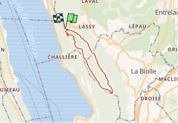
Montagne de la Biole variante

COMAN
User

Length
10.4 km

Max alt
843 m

Uphill gradient
342 m
Km-Effort
14.9 km

Min alt
642 m

Downhill gradient
340 m
Boucle
Yes
Creation date :
2016-06-01 00:00:00.0
Updated on :
2016-06-01 00:00:00.0
3h08
Difficulty : Easy

FREE GPS app for hiking
 SityTrail
IGN / Geographical institutes
SityTrail Plus
The world is yours!
About
Trail Walking of 10.4 km to be discovered at Auvergne-Rhône-Alpes, Savoy, Entrelacs. This trail is proposed by COMAN.
Description
Depuis la Chambotte belvedere, point de vue et croix de Meyrieu
Positioning
Country:
France
Region :
Auvergne-Rhône-Alpes
Department/Province :
Savoy
Municipality :
Entrelacs
Location:
Saint-Germain-la-Chambotte
Start:(Dec)
Start:(UTM)
723356 ; 5073292 (31T) N.
Comments