


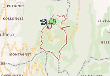
Le Clergeon

COMAN
User

Length
7.6 km

Max alt
1025 m

Uphill gradient
283 m
Km-Effort
11.4 km

Min alt
808 m

Downhill gradient
284 m
Boucle
Yes
Creation date :
2016-06-01 00:00:00.0
Updated on :
2016-06-01 00:00:00.0
2h26
Difficulty : Easy

FREE GPS app for hiking
 SityTrail
IGN / Geographical institutes
SityTrail Plus
The world is yours!
About
Trail Walking of 7.6 km to be discovered at Auvergne-Rhône-Alpes, Savoy, Ruffieux. This trail is proposed by COMAN.
Positioning
Country:
France
Region :
Auvergne-Rhône-Alpes
Department/Province :
Savoy
Municipality :
Ruffieux
Location:
Unknown
Start:(Dec)
Start:(UTM)
722607 ; 5081556 (31T) N.
Comments