


Beaulieu ouest

Gascon
User

Length
13.4 km

Max alt
62 m

Uphill gradient
142 m
Km-Effort
15.3 km

Min alt
24 m

Downhill gradient
142 m
Boucle
Yes
Creation date :
2016-06-02 00:00:00.0
Updated on :
2016-06-02 00:00:00.0
3h20
Difficulty : Easy

FREE GPS app for hiking
 SityTrail
IGN / Geographical institutes
SityTrail Plus
The world is yours!
About
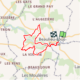
Trail Walking of 13.4 km to be discovered at Pays de la Loire, Vendée, Beaulieu-sous-la-Roche. This trail is proposed by Gascon.
Positioning
Country:
France
Region :
Pays de la Loire
Department/Province :
Vendée
Municipality :
Beaulieu-sous-la-Roche
Location:
Unknown
Start:(Dec)
Start:(UTM)
606892 ; 5170304 (30T) N.
Comments