


20160607-Tostes

doudet
User
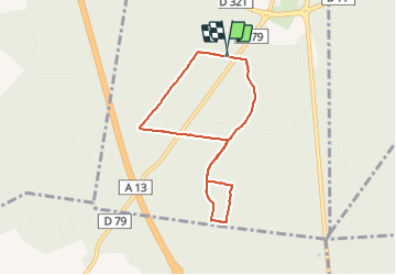

Length
6.4 km

Max alt
141 m

Uphill gradient
105 m
Km-Effort
7.8 km

Min alt
44 m

Downhill gradient
107 m
Boucle
Yes
Creation date :
2018-09-11 09:11:39.59
Updated on :
2018-09-11 09:11:39.59
1h42
Difficulty : Very easy

FREE GPS app for hiking
 SityTrail
IGN / Geographical institutes
SityTrail Plus
The world is yours!
About
Trail Walking of 6.4 km to be discovered at Normandy, Eure, Pont-de-l'Arche. This trail is proposed by doudet.
Description
Petite Boucle
Positioning
Country:
France
Region :
Normandy
Department/Province :
Eure
Municipality :
Pont-de-l'Arche
Location:
Unknown
Start:(Dec)
Start:(UTM)
365026 ; 5461460 (31U) N.
Comments