


REC Route Mamey 35

PhilippeC54
User
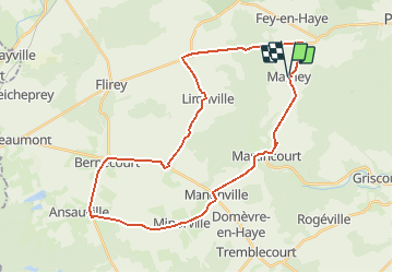

Length
34 km

Max alt
348 m

Uphill gradient
418 m
Km-Effort
39 km

Min alt
214 m

Downhill gradient
412 m
Boucle
Yes
Creation date :
2016-06-14 00:00:00.0
Updated on :
2016-06-14 00:00:00.0
2h16
Difficulty : Easy

FREE GPS app for hiking
 SityTrail
IGN / Geographical institutes
SityTrail Plus
The world is yours!
About
Trail Cycle of 34 km to be discovered at Grand Est, Meurthe-et-Moselle, Mamey. This trail is proposed by PhilippeC54.
Positioning
Country:
France
Region :
Grand Est
Department/Province :
Meurthe-et-Moselle
Municipality :
Mamey
Location:
Unknown
Start:(Dec)
Start:(UTM)
716940 ; 5418084 (31U) N.
Comments