


GTMC2_J7

PhilippeC54
User

Length
60 km

Max alt
559 m

Uphill gradient
770 m
Km-Effort
72 km

Min alt
-4 m

Downhill gradient
1163 m
Boucle
No
Creation date :
2016-06-14 00:00:00.0
Updated on :
2016-06-14 00:00:00.0
4h37
Difficulty : Medium

FREE GPS app for hiking
 SityTrail
IGN / Geographical institutes
SityTrail Plus
The world is yours!
About
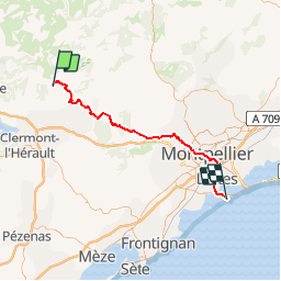
Trail Mountain bike of 60 km to be discovered at Occitania, Hérault, Montpeyroux. This trail is proposed by PhilippeC54.
Description
La Font du Griffe
Palavas
Positioning
Country:
France
Region :
Occitania
Department/Province :
Hérault
Municipality :
Montpeyroux
Location:
Unknown
Start:(Dec)
Start:(UTM)
539536 ; 4842400 (31T) N.
Comments