


ferme de l'étang

dehemjacques
User

Length
24 km

Max alt
160 m

Uphill gradient
267 m
Km-Effort
28 km

Min alt
95 m

Downhill gradient
277 m
Boucle
Yes
Creation date :
2016-06-16 00:00:00.0
Updated on :
2016-06-16 00:00:00.0
5h51
Difficulty : Medium

FREE GPS app for hiking
 SityTrail
IGN / Geographical institutes
SityTrail Plus
The world is yours!
About
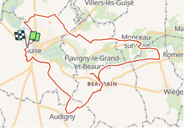
Trail Walking of 24 km to be discovered at Hauts-de-France, Aisne, Guise. This trail is proposed by dehemjacques.
Description
guise
Positioning
Country:
France
Region :
Hauts-de-France
Department/Province :
Aisne
Municipality :
Guise
Location:
Unknown
Start:(Dec)
Start:(UTM)
544750 ; 5527623 (31U) N.
Comments