


20160618-Beaumont-en Auge

doudet
User
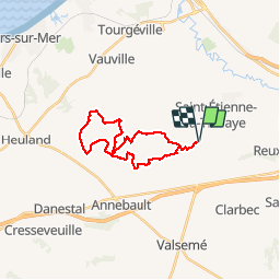

Length
21 km

Max alt
136 m

Uphill gradient
446 m
Km-Effort
27 km

Min alt
52 m

Downhill gradient
446 m
Boucle
Yes
Creation date :
2018-09-11 09:11:37.704
Updated on :
2018-09-11 09:11:37.704
5h44
Difficulty : Medium

FREE GPS app for hiking
 SityTrail
IGN / Geographical institutes
SityTrail Plus
The world is yours!
About
Trail Walking of 21 km to be discovered at Normandy, Calvados, Beaumont-en-Auge. This trail is proposed by doudet.
Description
Boucle A-R au départ de Beaumont en Auge
Chemins boueux
Positioning
Country:
France
Region :
Normandy
Department/Province :
Calvados
Municipality :
Beaumont-en-Auge
Location:
Unknown
Start:(Dec)
Start:(UTM)
289765 ; 5462463 (31U) N.
Comments