


Andelot-Morval 20160620

Bogapuki
User
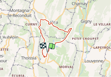

Length
11.5 km

Max alt
555 m

Uphill gradient
284 m
Km-Effort
15.3 km

Min alt
395 m

Downhill gradient
283 m
Boucle
Yes
Creation date :
2018-11-25 09:19:09.651
Updated on :
2018-11-25 09:19:09.651
3h17
Difficulty : Easy

FREE GPS app for hiking
 SityTrail
IGN / Geographical institutes
SityTrail Plus
The world is yours!
About
Trail Walking of 11.5 km to be discovered at Bourgogne-Franche-Comté, Jura, Andelot-Morval. This trail is proposed by Bogapuki.
Description
Joli paysage, beau château.
Photos


Positioning
Country:
France
Region :
Bourgogne-Franche-Comté
Department/Province :
Jura
Municipality :
Andelot-Morval
Location:
Unknown
Start:(Dec)
Start:(UTM)
685680 ; 5144395 (31T) N.
Comments