


Pic de Nore Roc de Nouret

rigol05
User
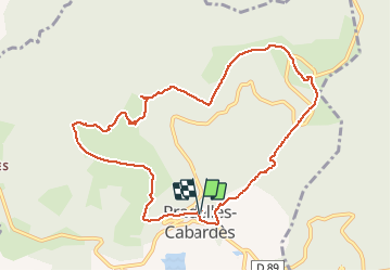

Length
10.9 km

Max alt
1214 m

Uphill gradient
518 m
Km-Effort
17.8 km

Min alt
810 m

Downhill gradient
517 m
Boucle
Yes
Creation date :
2016-11-22 00:00:00.0
Updated on :
2016-11-22 00:00:00.0
3h37
Difficulty : Medium

FREE GPS app for hiking
 SityTrail
IGN / Geographical institutes
SityTrail Plus
The world is yours!
About
Trail Walking of 10.9 km to be discovered at Occitania, Aude, Pradelles-Cabardès. This trail is proposed by rigol05.
Positioning
Country:
France
Region :
Occitania
Department/Province :
Aude
Municipality :
Pradelles-Cabardès
Location:
Unknown
Start:(Dec)
Start:(UTM)
455146 ; 4806334 (31T) N.
Comments