


ROSUEL - MONT POURRI

bourel.jacques
User
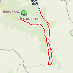

Length
13.1 km

Max alt
2363 m

Uphill gradient
978 m
Km-Effort
23 km

Min alt
1558 m

Downhill gradient
193 m
Boucle
No
Creation date :
2016-06-28 00:00:00.0
Updated on :
2016-06-28 00:00:00.0
5h16
Difficulty : Medium

FREE GPS app for hiking
 SityTrail
IGN / Geographical institutes
SityTrail Plus
The world is yours!
About
Trail Walking of 13.1 km to be discovered at Auvergne-Rhône-Alpes, Savoy, Peisey-Nancroix. This trail is proposed by bourel.jacques.
Positioning
Country:
France
Region :
Auvergne-Rhône-Alpes
Department/Province :
Savoy
Municipality :
Peisey-Nancroix
Location:
Unknown
Start:(Dec)
Start:(UTM)
328581 ; 5042874 (32T) N.
Comments