


Col de Plume Col de Faysse

rigol05
User
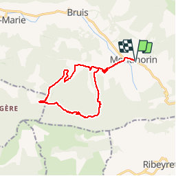

Length
14.1 km

Max alt
1169 m

Uphill gradient
534 m
Km-Effort
21 km

Min alt
753 m

Downhill gradient
532 m
Boucle
Yes
Creation date :
2016-07-04 00:00:00.0
Updated on :
2016-07-04 00:00:00.0
4h33
Difficulty : Easy

FREE GPS app for hiking
 SityTrail
IGN / Geographical institutes
SityTrail Plus
The world is yours!
About
Trail Walking of 14.1 km to be discovered at Provence-Alpes-Côte d'Azur, Hautes-Alpes, Valdoule. This trail is proposed by rigol05.
Description
Randonnée du 04/07/2016
Positioning
Country:
France
Region :
Provence-Alpes-Côte d'Azur
Department/Province :
Hautes-Alpes
Municipality :
Valdoule
Location:
Montmorin
Start:(Dec)
Start:(UTM)
702322 ; 4925003 (31T) N.
Comments
montmorin