


tour du lac de pétichet - la pierre percée

maupassant38
User
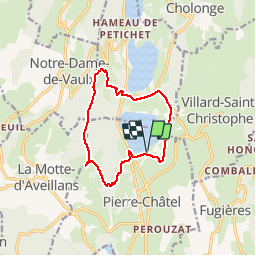

Length
11.3 km

Max alt
1275 m

Uphill gradient
410 m
Km-Effort
16.8 km

Min alt
931 m

Downhill gradient
411 m
Boucle
Yes
Creation date :
2019-02-22 22:31:14.146
Updated on :
2019-02-22 22:31:14.158
2h45
Difficulty : Medium

FREE GPS app for hiking
 SityTrail
IGN / Geographical institutes
SityTrail Plus
The world is yours!
About
Trail Walking of 11.3 km to be discovered at Auvergne-Rhône-Alpes, Isère, Pierre-Châtel. This trail is proposed by maupassant38.
Positioning
Country:
France
Region :
Auvergne-Rhône-Alpes
Department/Province :
Isère
Municipality :
Pierre-Châtel
Location:
Unknown
Start:(Dec)
Start:(UTM)
719243 ; 4983199 (31T) N.
Comments