Trail Snowshoes Valmeinier - Valmeinier - Lac de Roche Noir - les Vallons - Photo

Valmeinier - Lac de Roche Noir - les Vallons

© OpenStreetMap contributors
Length
Length
15 km
Max alt
Max alt
2538 m
Uphill gradient
Uphill gradient
1107 m
Km-Effort
Km-Effort  
29 km
Min alt
Min alt
1643 m
Downhill gradient
Downhill gradient
899 m
Boucle
Boucle
No
Creation date :
2016-07-10 00:00:00.0
Updated on :
2016-07-10 00:00:00.0

(0 Reviews)

Snowshoes
Snowshoes
4h40
Difficulty : Difficult

Scan this QR Code to open this trail in the SityTrail application

FREE GPS app for hiking

Logo SityTrail SityTrail

IGN / Geographical institutes

Download SityTrail from the App Store Download SityTrail from Google Play

Logo SityTrail SityTrail World

The world is yours!

Download SityTrail from the App Store Download SityTrail from Google Play Download SityTrail on Huawei AppGallery

About

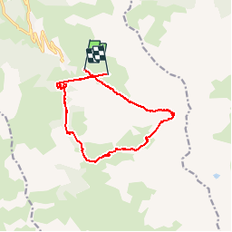
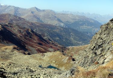
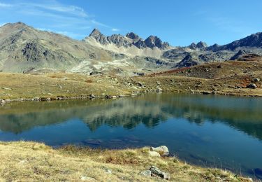
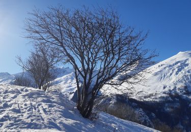
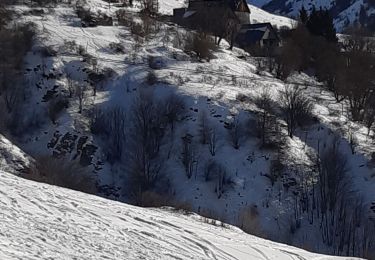
Trail Snowshoes of 15 km to be discovered at Auvergne-Rhône-Alpes, Savoy, Valmeinier. This trail is proposed by karawatsj.

Description

Mooie skitour rondtocht.
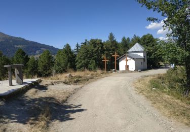
Vertrek vanuit Valmeinier 1800

Elevation profile

Photos

Points of interest

Point of interest Valmeinier - Point 3 - Photo
karawatsj
VALMEINIER 
Point of interest Valmeinier - Point 6 - Photo
karawatsj
VALMEINIER 

Positioning

Country:
France
Region :
Auvergne-Rhône-Alpes
Department/Province :
Savoy
Municipality :
Valmeinier
Location:
Unknown
Start:(UTM)
303660 ; 5005099 (32T) N.

Trails nearby

Trail Walking Valmeinier - Valmeinier 1800 Lac Vert - Photo
Walking
psesjs

Walking

Easy
(1)
Valmeinier, Auvergne-Rhône-Alpes, Savoy, France
4.2 km | 7.1 km-effort
Unknown
No
Trail Snowshoes Valmeinier - Refuge-Terre-Rouge-2024-01-14 - Photo
Snowshoes
Valmeinier

Snowshoes

Difficult
Valmeinier, Auvergne-Rhône-Alpes, Savoy, France
13.1 km | 20 km-effort
Unknown
Yes
Trail Walking Valmeinier - Col de la Roche du Lac-2023-10-08 - Photo
Walking
Valmeinier

Walking

Difficult
Valmeinier, Auvergne-Rhône-Alpes, Savoy, France
12.2 km | 27 km-effort
6h 5min
Yes
Trail Walking Valmeinier - Lac des Glaciers-2023-10-03 - Photo
Walking
Valmeinier

Walking

Difficult
Valmeinier, Auvergne-Rhône-Alpes, Savoy, France
20 km | 34 km-effort
7h 43min
Yes
Trail Walking Valloire - VALLOIRE :télégraphe trois croix valmeinier - Photo
Walking
lebarbe_b@hotmail.fr

Walking

Difficult
Valloire, Auvergne-Rhône-Alpes, Savoy, France
9.7 km | 14.5 km-effort
2h 43min
Yes
Trail Walking Valmeinier - Valmeinier-Lac de Curtalès - Photo
Walking
nicolas54230

Walking

Very difficult
(1)
Valmeinier, Auvergne-Rhône-Alpes, Savoy, France
18.6 km | 30 km-effort
6h 50min
Yes
Trail Walking Valmeinier - Valmeinier  - Photo
Walking
Limce

Walking

Very difficult
Valmeinier, Auvergne-Rhône-Alpes, Savoy, France
12.8 km | 24 km-effort
6h 11min
Yes
Trail Walking Valloire - le col,les 3 croix ,Lechaut,point rogereuil,retour par les Granges - Photo
Walking
marianne guichoux

Walking

Easy
Valloire, Auvergne-Rhône-Alpes, Savoy, France
7.9 km | 12.7 km-effort
2h 49min
Yes
Trail Walking Valloire - rando raquette le col chemin du facteur  l'Archaz Valloire - Photo
Walking
marianne guichoux

Walking

Medium
Valloire, Auvergne-Rhône-Alpes, Savoy, France
10.7 km | 15.8 km-effort
3h 29min
No


Close
My subscriptions