


les bernards

losjo
User
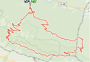

Length
23 km

Max alt
1499 m

Uphill gradient
1143 m
Km-Effort
38 km

Min alt
590 m

Downhill gradient
1144 m
Boucle
Yes
Creation date :
2018-03-15 00:00:00.0
Updated on :
2018-03-15 00:00:00.0
9h32
Difficulty : Medium

FREE GPS app for hiking
 SityTrail
IGN / Geographical institutes
SityTrail Plus
The world is yours!
About
Trail Walking of 23 km to be discovered at Provence-Alpes-Côte d'Azur, Vaucluse, Brantes. This trail is proposed by losjo.
Positioning
Country:
France
Region :
Provence-Alpes-Côte d'Azur
Department/Province :
Vaucluse
Municipality :
Brantes
Location:
Unknown
Start:(Dec)
Start:(UTM)
685767 ; 4895100 (31T) N.
Comments