


15 juillet

DaVinci
User

Length
13.3 km

Max alt
1174 m

Uphill gradient
578 m
Km-Effort
21 km

Min alt
649 m

Downhill gradient
578 m
Boucle
Yes
Creation date :
2016-07-15 00:00:00.0
Updated on :
2016-07-15 00:00:00.0
4h21
Difficulty : Unknown

FREE GPS app for hiking
 SityTrail
IGN / Geographical institutes
SityTrail Plus
The world is yours!
About
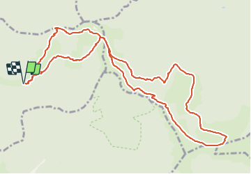
Trail Other activity of 13.3 km to be discovered at Grand Est, Haut-Rhin, Rimbach-près-Masevaux. This trail is proposed by DaVinci.
Positioning
Country:
France
Region :
Grand Est
Department/Province :
Haut-Rhin
Municipality :
Rimbach-près-Masevaux
Location:
Unknown
Start:(Dec)
Start:(UTM)
348065 ; 5299698 (32T) N.
Comments