


SF2016 Dim P4

PhilippeC54
User
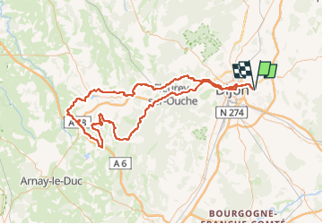

Length
138 km

Max alt
575 m

Uphill gradient
1804 m
Km-Effort
163 km

Min alt
222 m

Downhill gradient
1804 m
Boucle
Yes
Creation date :
2016-07-31 00:00:00.0
Updated on :
2016-07-31 00:00:00.0
7h33
Difficulty : Medium

FREE GPS app for hiking
 SityTrail
IGN / Geographical institutes
SityTrail Plus
The world is yours!
About
Trail Cycle of 138 km to be discovered at Bourgogne-Franche-Comté, Côte-d'Or, Quetigny. This trail is proposed by PhilippeC54.
Positioning
Country:
France
Region :
Bourgogne-Franche-Comté
Department/Province :
Côte-d'Or
Municipality :
Quetigny
Location:
Unknown
Start:(Dec)
Start:(UTM)
659509 ; 5242994 (31T) N.
Comments