


SF2016 Lun P2

PhilippeC54
User
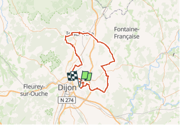

Length
100 km

Max alt
443 m

Uphill gradient
981 m
Km-Effort
113 km

Min alt
196 m

Downhill gradient
981 m
Boucle
Yes
Creation date :
2016-08-01 00:00:00.0
Updated on :
2016-08-01 00:00:00.0
4h40
Difficulty : Easy

FREE GPS app for hiking
 SityTrail
IGN / Geographical institutes
SityTrail Plus
The world is yours!
About
Trail Cycle of 100 km to be discovered at Bourgogne-Franche-Comté, Côte-d'Or, Quetigny. This trail is proposed by PhilippeC54.
Positioning
Country:
France
Region :
Bourgogne-Franche-Comté
Department/Province :
Côte-d'Or
Municipality :
Quetigny
Location:
Unknown
Start:(Dec)
Start:(UTM)
659514 ; 5243007 (31T) N.
Comments