


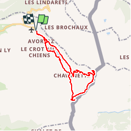
Rando Col des Chavenne

velofox
User

Length
15.4 km

Max alt
2220 m

Uphill gradient
741 m
Km-Effort
25 km

Min alt
1735 m

Downhill gradient
742 m
Boucle
Yes
Creation date :
2016-08-02 00:00:00.0
Updated on :
2016-08-02 00:00:00.0
6h20
Difficulty : Unknown

FREE GPS app for hiking
 SityTrail
IGN / Geographical institutes
SityTrail Plus
The world is yours!
About
Trail Walking of 15.4 km to be discovered at Auvergne-Rhône-Alpes, Upper Savoy, Morzine. This trail is proposed by velofox.
Description
et passage par le col des Fournet


Positioning
Country:
France
Region :
Auvergne-Rhône-Alpes
Department/Province :
Upper Savoy
Municipality :
Morzine
Location:
Unknown
Start:(Dec)
Start:(UTM)
327746 ; 5118385 (32T) N.
Comments
bois de l'abatide
4