


DOMREMY_18km

ZAMBAUX
User
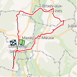

Length
18.3 km

Max alt
412 m

Uphill gradient
335 m
Km-Effort
23 km

Min alt
261 m

Downhill gradient
335 m
Boucle
Yes
Creation date :
2019-04-27 09:35:04.563
Updated on :
2019-04-27 09:35:04.616
4h53
Difficulty : Easy

FREE GPS app for hiking
 SityTrail
IGN / Geographical institutes
SityTrail Plus
The world is yours!
About
Trail Walking of 18.3 km to be discovered at Grand Est, Vosges, Domrémy-la-Pucelle. This trail is proposed by ZAMBAUX.
Positioning
Country:
France
Region :
Grand Est
Department/Province :
Vosges
Municipality :
Domrémy-la-Pucelle
Location:
Unknown
Start:(Dec)
Start:(UTM)
697845 ; 5368990 (31U) N.
Comments