


Les Ribes Charance chemin des vaches

Gegetop
User
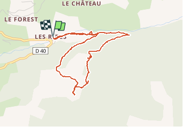

Length
5.1 km

Max alt
1735 m

Uphill gradient
292 m
Km-Effort
9 km

Min alt
1441 m

Downhill gradient
292 m
Boucle
Yes
Creation date :
2016-08-03 00:00:00.0
Updated on :
2016-08-03 00:00:00.0
2h03
Difficulty : Medium

FREE GPS app for hiking
 SityTrail
IGN / Geographical institutes
SityTrail Plus
The world is yours!
About
Trail Nordic walking of 5.1 km to be discovered at Provence-Alpes-Côte d'Azur, Hautes-Alpes, Les Orres. This trail is proposed by Gegetop.
Description
raidillon de mise en jambes
Positioning
Country:
France
Region :
Provence-Alpes-Côte d'Azur
Department/Province :
Hautes-Alpes
Municipality :
Les Orres
Location:
Unknown
Start:(Dec)
Start:(UTM)
306805 ; 4931691 (32T) N.
Comments