


Notre Dame de bon secours

Gegetop
User
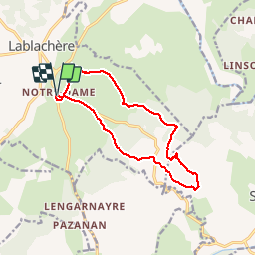

Length
13.5 km

Max alt
271 m

Uphill gradient
166 m
Km-Effort
15.7 km

Min alt
155 m

Downhill gradient
167 m
Boucle
Yes
Creation date :
2016-08-03 00:00:00.0
Updated on :
2016-08-03 00:00:00.0
3h27
Difficulty : Easy

FREE GPS app for hiking
 SityTrail
IGN / Geographical institutes
SityTrail Plus
The world is yours!
About
Trail Walking of 13.5 km to be discovered at Auvergne-Rhône-Alpes, Ardèche, Lablachère. This trail is proposed by Gegetop.
Description
Le point d'intérêt étant surtout l'Aven de Réméjadou avec ses imposants rochers de calcaire.


Positioning
Country:
France
Region :
Auvergne-Rhône-Alpes
Department/Province :
Ardèche
Municipality :
Lablachère
Location:
Unknown
Start:(Dec)
Start:(UTM)
597160 ; 4922897 (31T) N.
Comments