


20160806-Conches

doudet
User

Length
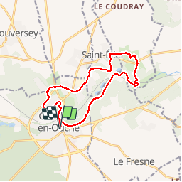
14.6 km

Max alt
160 m

Uphill gradient
201 m
Km-Effort
17.3 km

Min alt
97 m

Downhill gradient
202 m
Boucle
Yes
Creation date :
2018-09-11 09:11:33.19
Updated on :
2018-09-11 09:11:33.19
3h46
Difficulty : Easy

FREE GPS app for hiking
 SityTrail
IGN / Geographical institutes
SityTrail Plus
The world is yours!
About
Trail Walking of 14.6 km to be discovered at Normandy, Eure, Conches-en-Ouche. This trail is proposed by doudet.
Description
oucle A-R au dpart de l'Eglise de Conches
Positioning
Country:
France
Region :
Normandy
Department/Province :
Eure
Municipality :
Conches-en-Ouche
Location:
Unknown
Start:(Dec)
Start:(UTM)
349364 ; 5425047 (31U) N.
Comments