


20160807

fredodlageo
User
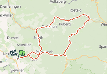

Length
41 km

Max alt
391 m

Uphill gradient
653 m
Km-Effort
50 km

Min alt
215 m

Downhill gradient
653 m
Boucle
Yes
Creation date :
2016-08-07 00:00:00.0
Updated on :
2016-08-07 00:00:00.0
2h14
Difficulty : Medium

FREE GPS app for hiking
 SityTrail
IGN / Geographical institutes
SityTrail Plus
The world is yours!
About
Trail Cycle of 41 km to be discovered at Grand Est, Bas-Rhin, Drulingen. This trail is proposed by fredodlageo.
Description
Sortie_route_vtt_electric
Positioning
Country:
France
Region :
Grand Est
Department/Province :
Bas-Rhin
Municipality :
Drulingen
Location:
Unknown
Start:(Dec)
Start:(UTM)
368517 ; 5413234 (32U) N.
Comments