


balade st Julien labrousse

raab
User
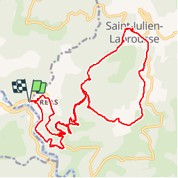

Length
15.7 km

Max alt
835 m

Uphill gradient
583 m
Km-Effort
23 km

Min alt
384 m

Downhill gradient
580 m
Boucle
Yes
Creation date :
2018-07-30 16:23:34.585
Updated on :
2018-07-30 16:23:34.607
6h00
Difficulty : Medium

FREE GPS app for hiking
 SityTrail
IGN / Geographical institutes
SityTrail Plus
The world is yours!
About
Trail Walking of 15.7 km to be discovered at Auvergne-Rhône-Alpes, Ardèche, Belsentes. This trail is proposed by raab.
Positioning
Country:
France
Region :
Auvergne-Rhône-Alpes
Department/Province :
Ardèche
Municipality :
Belsentes
Location:
Nonières
Start:(Dec)
Start:(UTM)
617117 ; 4973538 (31T) N.
Comments