


Hérin, variante des 4 clochers

papiou
User


1h58
Difficulty : Easy

FREE GPS app for hiking
 SityTrail
IGN / Geographical institutes
SityTrail Plus
The world is yours!
About
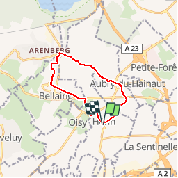
Trail Walking of 8.7 km to be discovered at Hauts-de-France, Nord, Hérin. This trail is proposed by papiou.
Description
Rdv parking salle des fêtes, passer devant église et prendre rue Ferrer pour rejoindre Aubry par chemin de terre, traverser Aubry par Malplaquet, les charmes puis Brossolette et du moulin. prendre à droite sentier d'Arenberg jusqu'au coucou. Au coucou à gauche vers Bellaing et suivre CD 313 et après cité des mines à droite rue Arras, au bout à gauche chemin piétonnier qui amène à Bellaing rue H.Durre, à gauche puis traverser CD 313 et prendre sentier herbeux jusqu'au CD 13 . rejoindre club hippique et prendre vers Hérin. à la rue V.Hugo, à gauche jusqu'à la voyette derrière les haies qui vous amène au parking du départ.
Photos


Positioning
Comments