


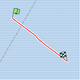
traversier Forestville Rimouski

emileverschueren
User

Length
5.7 km

Max alt
0 m

Uphill gradient
0 m
Km-Effort
5.7 km

Min alt
0 m

Downhill gradient
0 m
Boucle
No
Creation date :
2019-04-24 16:26:56.897
Updated on :
2019-04-24 16:26:57.792
7m
Difficulty : Unknown

FREE GPS app for hiking
 SityTrail
IGN / Geographical institutes
SityTrail World
The world is yours!
About
Trail Walking of 5.7 km to be discovered at Quebec, La Haute-Côte-Nord. This trail is proposed by emileverschueren.
Positioning
Country:
Canada
Region :
Quebec
Department/Province :
La Haute-Côte-Nord
Municipality :
Rivière du Sault aux Cochons
Location:
Unknown
Start:(Dec)
Start:(UTM)
497989 ; 5397947 (19U) N.
Comments
Trails nearby