


L'Hom-Barres des Cévennes

alfreson
User
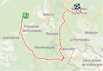

Length
35 km

Max alt
1268 m

Uphill gradient
851 m
Km-Effort
47 km

Min alt
891 m

Downhill gradient
981 m
Boucle
No
Creation date :
2016-08-10 00:00:00.0
Updated on :
2016-08-10 00:00:00.0
20h35
Difficulty : Easy

FREE GPS app for hiking
 SityTrail
IGN / Geographical institutes
SityTrail Plus
The world is yours!
About
Trail Equestrian of 35 km to be discovered at Occitania, Lozère, Fraissinet-de-Fourques. This trail is proposed by alfreson.
Description
On quitte les Causses pour les forêts vers les cols et le Mont Aiguoual
Photos


57 photos in total. Please click on a photo to see them all in the gallery.


Positioning
Country:
France
Region :
Occitania
Department/Province :
Lozère
Municipality :
Fraissinet-de-Fourques
Location:
Unknown
Start:(Dec)
Start:(UTM)
541107 ; 4897145 (31T) N.
Comments