


nono floflo

fredtruc27
User
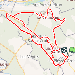

Length
38 km

Max alt
171 m

Uphill gradient
322 m
Km-Effort
43 km

Min alt
102 m

Downhill gradient
322 m
Boucle
Yes
Creation date :
2016-08-12 00:00:00.0
Updated on :
2016-08-12 00:00:00.0
3h04
Difficulty : Unknown

FREE GPS app for hiking
 SityTrail
IGN / Geographical institutes
SityTrail Plus
The world is yours!
About
Trail Other activity of 38 km to be discovered at Normandy, Eure, Les Baux-Sainte-Croix. This trail is proposed by fredtruc27.
Positioning
Country:
France
Region :
Normandy
Department/Province :
Eure
Municipality :
Les Baux-Sainte-Croix
Location:
Unknown
Start:(Dec)
Start:(UTM)
362980 ; 5424254 (31U) N.
Comments