


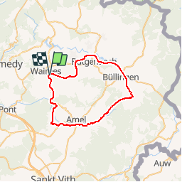
Waimes-Montenau-Honsfeld

leeho
User

Length
39 km

Max alt
633 m

Uphill gradient
524 m
Km-Effort
46 km

Min alt
420 m

Downhill gradient
520 m
Boucle
Yes
Creation date :
2016-08-13 00:00:00.0
Updated on :
2016-08-13 00:00:00.0
2h39
Difficulty : Easy

FREE GPS app for hiking
 SityTrail
IGN / Geographical institutes
SityTrail Plus
The world is yours!
About
Trail Cycle of 39 km to be discovered at Wallonia, Liège, Waimes. This trail is proposed by leeho.
Description
D'après la carte EuroVelo "Hautes Fagnes-Eiffel". Circuit au départ de l'ancienne gare de Waimes, empruntant le Ravel de la Vennbahn et routes secondaires. Retour par le Ravel de L45.
Positioning
Country:
Belgium
Region :
Wallonia
Department/Province :
Liège
Municipality :
Waimes
Location:
Waimes
Start:(Dec)
Start:(UTM)
295369 ; 5588166 (32U) N.
Comments