


De Frangy à Chaumont

COMAN
User
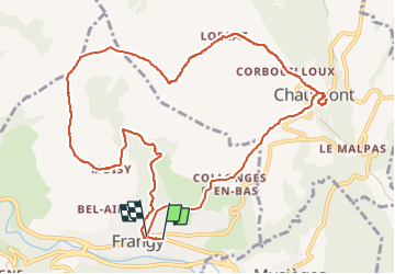

Length
12.2 km

Max alt
640 m

Uphill gradient
386 m
Km-Effort
17.3 km

Min alt
327 m

Downhill gradient
376 m
Boucle
Yes
Creation date :
2016-08-14 00:00:00.0
Updated on :
2016-08-14 00:00:00.0
4h47
Difficulty : Medium

FREE GPS app for hiking
 SityTrail
IGN / Geographical institutes
SityTrail Plus
The world is yours!
About
Trail Walking of 12.2 km to be discovered at Auvergne-Rhône-Alpes, Upper Savoy, Frangy. This trail is proposed by COMAN.
Description
Par les cascades et le chemin de Compostelle GR65
Photos

Positioning
Country:
France
Region :
Auvergne-Rhône-Alpes
Department/Province :
Upper Savoy
Municipality :
Frangy
Location:
Unknown
Start:(Dec)
Start:(UTM)
727052 ; 5100373 (31T) N.
Comments