


Solutré

florianlive
User
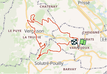

Length
13.9 km

Max alt
476 m

Uphill gradient
548 m
Km-Effort
21 km

Min alt
217 m

Downhill gradient
549 m
Boucle
Yes
Creation date :
2016-08-17 00:00:00.0
Updated on :
2016-08-17 00:00:00.0
3h40
Difficulty : Unknown

FREE GPS app for hiking
 SityTrail
IGN / Geographical institutes
SityTrail Plus
The world is yours!
About
Trail Other activity of 13.9 km to be discovered at Bourgogne-Franche-Comté, Saône-et-Loire, Davayé. This trail is proposed by florianlive.
Positioning
Country:
France
Region :
Bourgogne-Franche-Comté
Department/Province :
Saône-et-Loire
Municipality :
Davayé
Location:
Unknown
Start:(Dec)
Start:(UTM)
634149 ; 5129163 (31T) N.
Comments