Trail Walking Vialas - Sentier de l'Avès depuis le Coupétadou - Photo

Sentier de l'Avès depuis le Coupétadou

 alfreson
alfreson

User

© OpenStreetMap contributors
Length
Length
15.3 km
Max alt
Max alt
843 m
Uphill gradient
Uphill gradient
576 m
Km-Effort
Km-Effort  
23 km
Min alt
Min alt
434 m
Downhill gradient
Downhill gradient
569 m
Boucle
Boucle
Yes
Creation date :
2016-08-18 00:00:00.0
Updated on :
2016-08-18 00:00:00.0

(0 Reviews)

Walking
Walking
4h51
Difficulty : Medium

Scan this QR Code to open this trail in the SityTrail application

FREE GPS app for hiking

Logo SityTrail SityTrail

IGN / Geographical institutes

Download SityTrail from the App Store Download SityTrail from Google Play

Logo SityTrail SityTrail Plus

The world is yours!

Download SityTrail from the App Store Download SityTrail from Google Play Download SityTrail on Huawei AppGallery

About

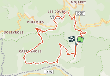
Trail Walking of 15.3 km to be discovered at Occitania, Lozère, Vialas. This trail is proposed by alfreson.

Description

Sentier découverte de l'Avès. Petite randonnée (PR) balisage jaune. Départ ici depuis notre chambre d'hôte, mais sinon départ depuis Vialas. Lieu de picnic et baignade à La Planche. Randonnée très belle, paysages variés, vue à 360 degrés depuis le col de la Banette et très joli village de Castagnols.

Elevation profile

Photos

54 photos in total. Please click on a photo to see them all in the gallery.

Points of interest

Point of interest Vialas - ancien moulin - Photo
alfreson

Positioning

Country:
France
Region :
Occitania
Department/Province :
Lozère
Municipality :
Vialas
Location:
Unknown
Start:(UTM)
572325 ; 4907993 (31T) N.


Close
My subscriptions