


La closette - Beauregard

luccho
User
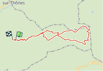

Length
11.1 km

Max alt
1628 m

Uphill gradient
547 m
Km-Effort
18.5 km

Min alt
1165 m

Downhill gradient
568 m
Boucle
Yes
Creation date :
2019-04-30 11:56:46.672
Updated on :
2019-04-30 11:56:46.793
3h56
Difficulty : Easy

FREE GPS app for hiking
 SityTrail
IGN / Geographical institutes
SityTrail Plus
The world is yours!
About
Trail Walking of 11.1 km to be discovered at Auvergne-Rhône-Alpes, Upper Savoy, Thônes. This trail is proposed by luccho.
Photos


Positioning
Country:
France
Region :
Auvergne-Rhône-Alpes
Department/Province :
Upper Savoy
Municipality :
Thônes
Location:
Unknown
Start:(Dec)
Start:(UTM)
295377 ; 5084965 (32T) N.
Comments