


Vercors - col de l'allimas

luccho
User

Length
13.7 km

Max alt
1743 m

Uphill gradient
711 m
Km-Effort
23 km

Min alt
1106 m

Downhill gradient
715 m
Boucle
Yes
Creation date :
2019-04-30 11:56:46.261
Updated on :
2019-04-30 11:56:46.316
4h53
Difficulty : Easy

FREE GPS app for hiking
 SityTrail
IGN / Geographical institutes
SityTrail Plus
The world is yours!
About
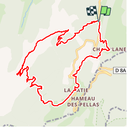
Trail Walking of 13.7 km to be discovered at Auvergne-Rhône-Alpes, Isère, Gresse-en-Vercors. This trail is proposed by luccho.
Description
Boucle depuis le col de l'Allimas avec vu sur le mont Aiguille et montée au Petit Vermont - superbe balade
Positioning
Country:
France
Region :
Auvergne-Rhône-Alpes
Department/Province :
Isère
Municipality :
Gresse-en-Vercors
Location:
Unknown
Start:(Dec)
Start:(UTM)
702717 ; 4973017 (31T) N.
Comments