


Etang d'En Beys

petit-pied
User
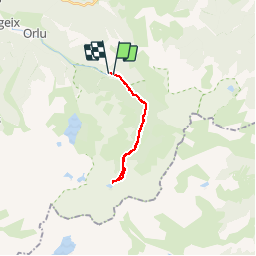

Length
18.9 km

Max alt
2003 m

Uphill gradient
936 m
Km-Effort
31 km

Min alt
1127 m

Downhill gradient
942 m
Boucle
No
Creation date :
2019-04-14 17:15:07.169
Updated on :
2019-04-14 17:15:07.271
6h27
Difficulty : Medium

FREE GPS app for hiking
 SityTrail
IGN / Geographical institutes
SityTrail Plus
The world is yours!
About
Trail Walking of 18.9 km to be discovered at Occitania, Ariège, Orlu. This trail is proposed by petit-pied.
Positioning
Country:
France
Region :
Occitania
Department/Province :
Ariège
Municipality :
Orlu
Location:
Unknown
Start:(Dec)
Start:(UTM)
413472 ; 4725931 (31T) N.
Comments