


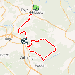
Jalhay - Sart - La Hoegne

GANET
User

Length
24 km

Max alt
598 m

Uphill gradient
479 m
Km-Effort
30 km

Min alt
284 m

Downhill gradient
504 m
Boucle
No
Creation date :
2016-12-05 00:00:00.0
Updated on :
2016-12-05 00:00:00.0
6h28
Difficulty : Easy

FREE GPS app for hiking
 SityTrail
IGN / Geographical institutes
SityTrail Plus
The world is yours!
About
Trail Walking of 24 km to be discovered at Wallonia, Liège, Jalhay. This trail is proposed by GANET.
Description
Jalhay
Positioning
Country:
Belgium
Region :
Wallonia
Department/Province :
Liège
Municipality :
Jalhay
Location:
Jalhay
Start:(Dec)
Start:(UTM)
710171 ; 5604929 (31U) N.
Comments