


tréminis/le serre - grotte de la fétoure

maupassant38
User
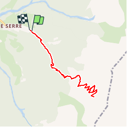

Length
8.6 km

Max alt
2051 m

Uphill gradient
957 m
Km-Effort
21 km

Min alt
1064 m

Downhill gradient
962 m
Boucle
Yes
Creation date :
2019-02-22 22:31:11.586
Updated on :
2019-02-22 22:31:11.596
4h07
Difficulty : Medium

FREE GPS app for hiking
 SityTrail
IGN / Geographical institutes
SityTrail Plus
The world is yours!
About
Trail Walking of 8.6 km to be discovered at Auvergne-Rhône-Alpes, Isère, Tréminis. This trail is proposed by maupassant38.
Positioning
Country:
France
Region :
Auvergne-Rhône-Alpes
Department/Province :
Isère
Municipality :
Tréminis
Location:
Unknown
Start:(Dec)
Start:(UTM)
720818 ; 4957926 (31T) N.
Comments