


sallenelles

thle
User
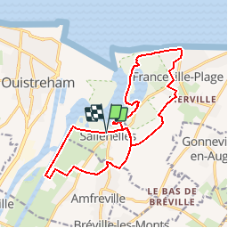

Length
16.2 km

Max alt
49 m

Uphill gradient
117 m
Km-Effort
17.8 km

Min alt
-1 m

Downhill gradient
120 m
Boucle
Yes
Creation date :
2016-09-01 00:00:00.0
Updated on :
2016-09-01 00:00:00.0
2h13
Difficulty : Easy

FREE GPS app for hiking
 SityTrail
IGN / Geographical institutes
SityTrail Plus
The world is yours!
About
Trail Equestrian of 16.2 km to be discovered at Normandy, Calvados, Sallenelles. This trail is proposed by thle.
Positioning
Country:
France
Region :
Normandy
Department/Province :
Calvados
Municipality :
Sallenelles
Location:
Unknown
Start:(Dec)
Start:(UTM)
701426 ; 5460546 (30U) N.
Comments