![](/images/other/stat-length.png)
![Trail Walking Mérignies - Mérignies par le PP - Photo](https://media.geolcdn.com/t/1900/400/ext.pjpeg?maxdim=2&url=https%3A%2F%2Fstatic1.geolcdn.com%2Fsiteimages%2Fupload%2Ffiles%2F1553511878bg_sport_marche.png)
Mérignies par le PP
dehemjacques
User
![Length](/images/other/stat-length.png)
Length
13.6 km
![Max alt](https://static1.geolcdn.com/siteimages/upload/files/1508320355ic_sort_altitude_max_24dp.png)
Max alt
74 m
![Uphill gradient](https://static1.geolcdn.com/siteimages/upload/files/1508320355ic_sort_den_pos_24dp.png)
Uphill gradient
82 m
![Km-Effort](/images/other/stat-length.png)
Km-Effort
14.7 km
![Min alt](https://static1.geolcdn.com/siteimages/upload/files/1508320355ic_sort_altitude_min_24dp.png)
Min alt
30 m
![Downhill gradient](https://static1.geolcdn.com/siteimages/upload/files/1508320355ic_sort_den_neg_24dp.png)
Downhill gradient
82 m
![Boucle](https://static1.geolcdn.com/siteimages/upload/files/16400158638029165_repeat_loop_refresh_sync_direction_icon.png)
Boucle
Yes
Creation date :
2016-09-02 00:00:00.0
Updated on :
2016-09-02 00:00:00.0
![Walking](https://static1.geolcdn.com/sitytour/trail-icons/101.png)
3h30
Difficulty : Easy
![Scan this QR Code to open this trail in the SityTrail application](https://capi.geolives.com/qq0zvz2zws4bq2lad0pu/sitytour/trails/624829/qr.png?size=200)
FREE GPS app for hiking
About
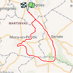
Trail Walking of 13.6 km to be discovered at Hauts-de-France, Nord, Mérignies. This trail is proposed by dehemjacques.
Description
Départ Salle de sports de Mérignies à Gare de Mons en Pévéle par le PP (8,8 kms) puis retour par contour du cimetière de Mons en Pévèle, chemin de la Quempoinne, la petite vincourt, le pavé du blocus et Mérignies
Positioning
Country:
France
Region :
Hauts-de-France
Department/Province :
Nord
Municipality :
Mérignies
Location:
Unknown
Start:(Dec)
Start:(UTM)
507943 ; 5594394 (31U) N.
Comments
Trails nearby
![Trail Equestrian Cappelle-en-Pévèle - Boucle des Pavés - Capelle en Pévèle - Photo](https://media.geolcdn.com/t/375/260/ext.jpg?maxdim=2&url=https%3A%2F%2Fservices.sitytrail.com%2FGeolivesWS%2FDownloadMedia.ashx%3FTrailID%3D172678%26Media%3D14060_5.jpg)
![Equestrian Equestrian](https://static1.geolcdn.com/sitytour/trail-icons/300.png)
Boucle des Pavés - Capelle en Pévèle
Equestrian
Medium
(1)
Cappelle-en-Pévèle,
Hauts-de-France,
Nord,
France
![](/images/other/stat-length.png)
17.7 km | 18.7 km-effort
2h 45min
![](https://static1.geolcdn.com/siteimages/upload/files/16400158638029165_repeat_loop_refresh_sync_direction_icon.png)
Yes
![Trail Walking Ennevelin - Circuit d'Aigremont - Photo](https://media.geolcdn.com/t/375/260/ext.jpg?maxdim=2&url=https%3A%2F%2Fservices.sitytrail.com%2FGeolivesWS%2FDownloadMedia.ashx%3FTrailID%3D109029%26Media%3D2987_6.jpg)
![Walking Walking](https://static1.geolcdn.com/sitytour/trail-icons/101.png)
Circuit d'Aigremont
Walking
Medium
(1)
Ennevelin,
Hauts-de-France,
Nord,
France
![](/images/other/stat-length.png)
11.1 km | 11.8 km-effort
2h 45min
![](https://static1.geolcdn.com/siteimages/upload/files/16400158638029165_repeat_loop_refresh_sync_direction_icon.png)
Yes
![Trail Walking Mons-en-Pévèle - Autour du site ornithologique du bois des Cinq Tailles - Mons en Pévèle - Photo](https://media.geolcdn.com/t/375/260/ext.jpg?maxdim=2&url=https%3A%2F%2Fservices.sitytrail.com%2FGeolivesWS%2FDownloadMedia.ashx%3FTrailID%3D107326%26Media%3D12216_6.jpg)
![Walking Walking](https://static1.geolcdn.com/sitytour/trail-icons/101.png)
Autour du site ornithologique du bois des Cinq Tailles - Mons en Pévèle
Walking
Medium
(4)
Mons-en-Pévèle,
Hauts-de-France,
Nord,
France
![](/images/other/stat-length.png)
11.2 km | 12.8 km-effort
2h 49min
![](https://static1.geolcdn.com/siteimages/upload/files/16400158638029165_repeat_loop_refresh_sync_direction_icon.png)
Yes
![Trail Walking Mons-en-Pévèle - Autour du château d'Assignies à Tourmignies - Mons-en-Pévèle - Photo](https://media.geolcdn.com/t/375/260/ext.jpg?maxdim=2&url=https%3A%2F%2Fservices.sitytrail.com%2FGeolivesWS%2FDownloadMedia.ashx%3FTrailID%3D107253%26Media%3D12133_6.jpg)
![Walking Walking](https://static1.geolcdn.com/sitytour/trail-icons/101.png)
Autour du château d'Assignies à Tourmignies - Mons-en-Pévèle
Walking
Difficult
(2)
Mons-en-Pévèle,
Hauts-de-France,
Nord,
France
![](/images/other/stat-length.png)
12.9 km | 14.3 km-effort
3h 15min
![](https://static1.geolcdn.com/siteimages/upload/files/16400158638029165_repeat_loop_refresh_sync_direction_icon.png)
Yes
![Trail Walking Mons-en-Pévèle - Autour des Voyettes - Mons-en-Pévèle - Photo](https://media.geolcdn.com/t/375/260/ext.jpg?maxdim=2&url=https%3A%2F%2Fservices.sitytrail.com%2FGeolivesWS%2FDownloadMedia.ashx%3FTrailID%3D107254%26Media%3D12134_6.jpg)
![Walking Walking](https://static1.geolcdn.com/sitytour/trail-icons/101.png)
Autour des Voyettes - Mons-en-Pévèle
Walking
Easy
(1)
Mons-en-Pévèle,
Hauts-de-France,
Nord,
France
![](/images/other/stat-length.png)
3 km | 3.6 km-effort
45min
![](https://static1.geolcdn.com/siteimages/upload/files/16400158638029165_repeat_loop_refresh_sync_direction_icon.png)
Yes
![Trail Walking Mons-en-Pévèle - le paradis de mons en pévèle - Photo](https://media.geolcdn.com/t/375/260/ext.jpg?maxdim=2&url=https%3A%2F%2Fstatic1.geolcdn.com%2Fsiteimages%2Fupload%2Ffiles%2F1553511878bg_sport_marche.png)
![Walking Walking](https://static1.geolcdn.com/sitytour/trail-icons/101.png)
le paradis de mons en pévèle
Walking
Easy
(1)
Mons-en-Pévèle,
Hauts-de-France,
Nord,
France
![](/images/other/stat-length.png)
8.6 km | 9.8 km-effort
2h 15min
![](https://static1.geolcdn.com/siteimages/upload/files/16400158638029165_repeat_loop_refresh_sync_direction_icon.png)
Yes
![Trail Walking Mons-en-Pévèle - Mons-en-Pévèle - balisage 2024 - Photo](https://media.geolcdn.com/t/375/260/ext.jpg?maxdim=2&url=https%3A%2F%2Fmedia.geolcdn.com%2Ff%2F5a656f5f-9962-482e-97b7-05e2eb1abacc.jpg)
![Walking Walking](https://static1.geolcdn.com/sitytour/trail-icons/101.png)
Mons-en-Pévèle - balisage 2024
Walking
Difficult
Mons-en-Pévèle,
Hauts-de-France,
Nord,
France
![](/images/other/stat-length.png)
11.7 km | 13.2 km-effort
3h 21min
![](https://static1.geolcdn.com/siteimages/upload/files/16400158638029165_repeat_loop_refresh_sync_direction_icon.png)
No
![Trail Walking Avelin - circuit des chicons - Photo](https://media.geolcdn.com/t/375/260/ext.jpg?maxdim=2&url=https%3A%2F%2Fmedia.geolcdn.com%2Ff%2Fc6c11125-df6c-403a-9c62-53c8254f7d6d.jpg)
![Walking Walking](https://static1.geolcdn.com/sitytour/trail-icons/101.png)
circuit des chicons
Walking
Easy
Avelin,
Hauts-de-France,
Nord,
France
![](/images/other/stat-length.png)
11.7 km | 12.5 km-effort
2h 21min
![](https://static1.geolcdn.com/siteimages/upload/files/16400158638029165_repeat_loop_refresh_sync_direction_icon.png)
Yes
![Trail Walking Ennevelin - GR121B Phalempin à Ennevelin - Photo](https://media.geolcdn.com/t/375/260/ext.jpg?maxdim=2&url=https%3A%2F%2Fstatic1.geolcdn.com%2Fsiteimages%2Fupload%2Ffiles%2F1553511878bg_sport_marche.png)
![Walking Walking](https://static1.geolcdn.com/sitytour/trail-icons/101.png)
GR121B Phalempin à Ennevelin
Walking
Easy
(2)
Ennevelin,
Hauts-de-France,
Nord,
France
![](/images/other/stat-length.png)
14.4 km | 15.6 km-effort
3h 28min
![](https://static1.geolcdn.com/siteimages/upload/files/16400158638029165_repeat_loop_refresh_sync_direction_icon.png)
No