


Bollènesept2016

ramsay
User
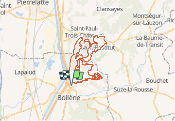

Length
52 km

Max alt
313 m

Uphill gradient
1030 m
Km-Effort
66 km

Min alt
58 m

Downhill gradient
1028 m
Boucle
Yes
Creation date :
2018-04-12 14:10:55.608
Updated on :
2018-04-12 14:10:55.608
--
Difficulty : Difficult

FREE GPS app for hiking
 SityTrail
IGN / Geographical institutes
SityTrail Plus
The world is yours!
About
Trail Mountain bike of 52 km to be discovered at Provence-Alpes-Côte d'Azur, Vaucluse, Bollène. This trail is proposed by ramsay.
Positioning
Country:
France
Region :
Provence-Alpes-Côte d'Azur
Department/Province :
Vaucluse
Municipality :
Bollène
Location:
Unknown
Start:(Dec)
Start:(UTM)
639837 ; 4905843 (31T) N.
Comments