


glieres_champlaitier_spee tdt

luccho
User
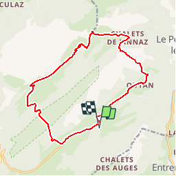

Length
16.4 km

Max alt
1726 m

Uphill gradient
760 m
Km-Effort
27 km

Min alt
1353 m

Downhill gradient
759 m
Boucle
Yes
Creation date :
2019-04-30 11:56:43.657
Updated on :
2019-04-30 11:56:43.785
5h29
Difficulty : Easy

FREE GPS app for hiking
 SityTrail
IGN / Geographical institutes
SityTrail Plus
The world is yours!
About
Trail Walking of 16.4 km to be discovered at Auvergne-Rhône-Alpes, Upper Savoy, Glières-Val-de-Borne. This trail is proposed by luccho.
Positioning
Country:
France
Region :
Auvergne-Rhône-Alpes
Department/Province :
Upper Savoy
Municipality :
Glières-Val-de-Borne
Location:
Le Petit-Bornand-les-Glières
Start:(Dec)
Start:(UTM)
294739 ; 5094400 (32T) N.
Comments