Trail Walking Cerdon - BMF-160904 - Aubigny-ÉtangPuits - Photo

BMF-160904 - Aubigny-ÉtangPuits

 randodan
randodan

User

© OpenStreetMap contributors
Length
Length
8.5 km
Max alt
Max alt
175 m
Uphill gradient
Uphill gradient
52 m
Km-Effort
Km-Effort  
9.2 km
Min alt
Min alt
160 m
Downhill gradient
Downhill gradient
56 m
Boucle
Boucle
Yes
Creation date :
2016-11-03 00:00:00.0
Updated on :
2016-11-03 00:00:00.0

(0 Reviews)

Walking
Walking
2h10
Difficulty : Very easy

Scan this QR Code to open this trail in the SityTrail application

FREE GPS app for hiking

Logo SityTrail SityTrail

IGN / Geographical institutes

Download SityTrail from the App Store Download SityTrail from Google Play

Logo SityTrail SityTrail Plus

The world is yours!

Download SityTrail from the App Store Download SityTrail from Google Play Download SityTrail on Huawei AppGallery

About

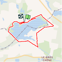
Trail Walking of 8.5 km to be discovered at Centre-Loire Valley, Loiret, Cerdon. This trail is proposed by randodan.

Description

WE camping Aubigny<br>
- 04 septembre 2016 -<br>
10h20, après un faux départ vers l'Ouest, Cap à l'Est pour le tour de l’Étang du Puits. Belle gamelle pour moi sur le sentier le long d'une ancienne voie ferrée.<br>
12h30, la boucle est bouclée et on s'installe près de la plage pour pique-niquer.

Elevation profile

Points of interest

Point of interest Cerdon - 01 - L'Étang du Puits - Photo
randodan

Positioning

Country:
France
Region :
Centre-Loire Valley
Department/Province :
Loiret
Municipality :
Cerdon
Location:
Unknown
Start:(UTM)
453318 ; 5271339 (31T) N.


Close
My subscriptions