Trail Other activity Rieux-Volvestre - Rieux Plaine des Gaulois  - Photo

Rieux Plaine des Gaulois

 pidjam
pidjam

User

© OpenStreetMap contributors
Length
Length
12.8 km
Max alt
Max alt
271 m
Uphill gradient
Uphill gradient
179 m
Km-Effort
Km-Effort  
15.1 km
Min alt
Min alt
207 m
Downhill gradient
Downhill gradient
176 m
Boucle
Boucle
Yes
Creation date :
2016-09-09 00:00:00.0
Updated on :
2016-09-09 00:00:00.0

(0 Reviews)

Other activity
Other activity
3h21
Difficulty : Easy

Scan this QR Code to open this trail in the SityTrail application

FREE GPS app for hiking

Logo SityTrail SityTrail

IGN / Geographical institutes

Download SityTrail from the App Store Download SityTrail from Google Play

Logo SityTrail SityTrail World

The world is yours!

Download SityTrail from the App Store Download SityTrail from Google Play Download SityTrail on Huawei AppGallery

About

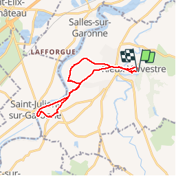
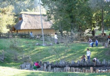
Trail Other activity of 12.8 km to be discovered at Occitania, Haute-Garonne, Rieux-Volvestre. This trail is proposed by pidjam.

Description

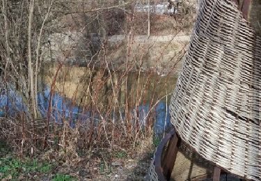
Balade variée à éviter en temps pluvieux (traverse de Beaulieu très pentue);la zone de falaise effondrée à éviter est indiquée (le balisage jaune est juste sauf aux abords du village Gaulois)

Elevation profile

Photos

Positioning

Country:
France
Region :
Occitania
Department/Province :
Haute-Garonne
Municipality :
Rieux-Volvestre
Location:
Unknown
Start:(UTM)
354228 ; 4790890 (31T) N.

Trails nearby

Trail On foot Carbonne - Balade des coteaux - Photo
On foot
PRO

On foot

Easy
Carbonne, Occitania, Haute-Garonne, France
3.2 km | 5.1 km-effort
1h 9min
No
Trail On foot Rieux-Volvestre - Pissevinaigre - Photo
On foot
PRO

On foot

Easy
Rieux-Volvestre, Occitania, Haute-Garonne, France
6.3 km | 8.4 km-effort
1h 54min
Yes
Trail On foot Rieux-Volvestre - Le chemin de Saint-Roc - Photo
On foot
PRO

On foot

Easy
Rieux-Volvestre, Occitania, Haute-Garonne, France
3.5 km | 4.8 km-effort
1h 5min
No
Trail Walking Rieux-Volvestre - Belberaud 7km - Photo
Walking
pidjam

Walking

Very easy
Rieux-Volvestre, Occitania, Haute-Garonne, France
61 km | 80 km-effort
5h 22min
No
Trail Walking Carbonne - Carbonne abris - Photo
Walking
pidjam

Walking

Very easy
Carbonne, Occitania, Haute-Garonne, France
11.1 km | 13.3 km-effort
2h 25min
Yes
Trail Running Rieux-Volvestre - Du bourg médévial de Rieux Volvestre au village gaulois de St Julien - Photo
Running
tracegps

Running

Medium
Rieux-Volvestre, Occitania, Haute-Garonne, France
12.2 km | 14.3 km-effort
1h 0min
Yes
Trail Mountain bike Rieux-Volvestre - Du bourg médévial de Rieux Volvestre au village gaulois de St Julien - Photo
Mountain bike
tracegps

Mountain bike

Easy
Rieux-Volvestre, Occitania, Haute-Garonne, France
12.2 km | 14.3 km-effort
45min
Yes
Trail Walking Rieux-Volvestre - Du bourg médévial de Rieux Volvestre au village gaulois de St Julien - Photo
Walking
tracegps

Walking

Medium
Rieux-Volvestre, Occitania, Haute-Garonne, France
12.2 km | 14.3 km-effort
3h 0min
Yes
Trail On foot Rieux-Volvestre - De la Cathédrale au chemin de la Coque et du Vila - Photo
On foot
PRO

On foot

Easy
Rieux-Volvestre, Occitania, Haute-Garonne, France
3.9 km | 5.4 km-effort
1h 13min
No


Close
My subscriptions